The Columbia River is one of the largest rivers in North America and drains an enormous watershed across several states.
As the river flows toward the Pacific Ocean, it carries and deposits rocks and minerals from many different sources along its tributaries, including rivers that originate far away in the Rocky Mountains, such as the Yellowstone River system, as well as other major tributaries within the Columbia Basin.
Over thousands of years, this process has mixed material from many geological regions into the Columbia River’s gravel bars and banks.
Why the Columbia River Has So Many Unique Rocks?
Much of eastern Washington is covered by the Columbia River Basalt Group, a massive series of lava flows that erupted between about 17 and 6 million years ago and spread across Washington, Oregon, and Idaho.
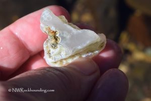
When these basalt flows cooled, gas bubbles were trapped inside the rock. Over time, groundwater rich in silica filled these cavities and formed minerals such as chalcedony, quartz, and agate.
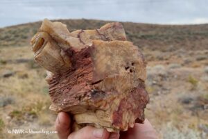
As a result, the Columbia River contains agates, chalcedony, jasper, quartz, basalt geodes, and petrified wood. The river also carries a mix of other stones from upstream, including granite, quartzite, unakite, and some metamorphic rocks, along with green minerals like serpentine and epidote.
River erosion and seasonal flooding continue to expose these materials in gravel bars and along the banks.

Rockhounding Restrictions along the Columbia River
However, being along a river does not automatically mean collecting is permitted. Along the Columbia River, access and collecting rules depend on who manages each section of land.
Large sections of the riverbank are managed by federal agencies such as the U.S. Army Corps of Engineers, the National Park Service (NPS), and the U.S. Fish and Wildlife Service, as well as local agencies, including the Washington Department of Fish and Wildlife and various state, county, and city parks.
These lands often include recreation areas, wildlife refuges, and protected habitats, where collecting rocks, minerals, or fossils is typically prohibited.
Limited Bureau of Land Management (BLM) parcels
BLM manages a small number of parcels near the Columbia Basin where limited recreational collecting of common rocks and minerals for personal use may be allowed.
Along the Columbia River, these parcels are scattered and relatively small, with one located east of Arlington on the Oregon side and another near Roosevelt in Washington.
Because these areas are not widely publicized and may require crossing railroad tracks or private land, access should always be evaluated carefully.

Beware of Incorrect Rockhounding Guides
Some websites and rockhounding books list collecting sites directly along the Columbia River. However, many of these locations fall within wildlife refuges, national recreation areas, parks, or other protected lands where collecting rocks, minerals, or fossils is not allowed.
Columbia River at Kettle Falls
The Columbia River at Kettle Falls is sometimes mentioned in guidebooks as a rockhounding location. However, areas such as Colville Flats Day Use Area and nearby Lions Island are part of Lake Roosevelt National Recreation Area, managed by the National Park Service.
Like most units of the National Park System, this area follows a strict “leave what you find” policy. Collecting rocks, minerals, fossils, or artifacts is not permitted, even from riverbanks or exposed gravel bars.
Sand Hollow Recreation Area
Sand Hollow Recreation Area is managed by Grant County as part of its public recreation lands along the Columbia Basin.
While it may appear open and accessible, collecting rocks or minerals is generally not allowed under county land-use rules, which prioritize recreation, habitat protection, and preservation of natural features.
Visitors should treat the area as a no-collecting site.
Vernita Bridge Boat Launch
Some rockhounding sources recommend the Vernita Bridge Boat Launch area, but this location is managed by the U.S. Fish and Wildlife Service as part of the Hanford Reach National Monument.
This is a protected habitat area, and collecting rocks, minerals, fossils, or other natural materials is not allowed. Regulations here are focused on conserving wildlife and maintaining the natural landscape.
Even in places where collecting is not allowed, the Columbia River shoreline remains an excellent place to explore geology, find interesting basalt formations, as well as a wide variety of rocks and minerals exposed in river gravels, observe and photograph what you discover.
You May Also Like