

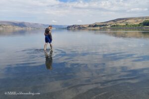
The Little Naches area is about 47 miles northwest of Yakima, in the Okanogan-Wenatchee National Forest. It is a popular year-round destination and offers many outdoor activities in a beautiful natural setting.
This area is also a good place for rockhounding, where you can find materials like agate, jasper, and blue-gray chalcedony. It is especially known for thundereggs, which are fairly rare in Washington State.
Little Naches Thunderegg Rockhounding
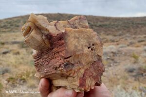
The hills in the Quartz Creek area near the river are especially notable for producing thundereggs filled with blue-gray-white agate, often accompanied by quartz. Unique lily pad jasper thundereggs and leaf fossils are also found here.
There are a few beds in the area, and each produces material with its own characteristics. The most notable are Bed #1 and Bed #2.
Little Naches - Bed#1
Agate thundereggs from this deposit exhibit distinctive features such as banding, feather patterns, waterlines, and orange streaks throughout the matrix.
The dig site is a 0.5-mile hike from the trailhead, where you'll find numerous pits left by previous collectors. You can continue digging in old pits if they look promising or start your own. You'll need a shovel or pick. If the eggs are attached to host rocks, use a hammer and chisel.

Little Naches Bed#2 - Lily Pad Thundereggs
These thundereggs are especially unique and, as the name suggests, resemble lily pads. The specimens have a bluish jasper core, often outlined by orange material and surrounded by tan, whitish, or greenish matrix. Sometimes, quartz pockets are present.
The lily pad deposits sit along the road, so no long hikes are required.

Beyond the Rocks: Exploring the Area
Outdoor enthusiasts can enjoy various activities such as camping, hiking, fishing, rafting, and swimming.
The region features an extensive trail network suited for hiking, mountain biking, off-highway vehicle (OHV) riding, and snowmobiling.
Among the most popular trails are Kaner Flat Trail and the Frost Mountain Lookout Trail, both offering breathtaking views of conifer forests and surrounding mountains.
A notable nearby attraction is the Boulder Cave National Recreation Trail, a popular destination near Naches. Visitors can enjoy a walk along the accessible trail by the river or explore Boulder Cave itself. The trail features interpretive signs that provide insights into the area's geology, flora, fauna, and fire history.
Little Naches Thunder eggs Collecting Areas | Facts
Material: Thundereggs
Tools: Rock hammer, shovel, gad pry bar, and chisel
Land type: Forested hills
Best time to visit: From May to October
Land Manager: US Forest Service - Okanogan-Wenatchee National Forest
Fees: None
Location: 47 miles northwest of Yakima • Washington • USA
Road access: Any vehicle
Elevation: 3,700 ft (1,120 m)
Places to Stay Near Little Naches River Area
The Little Naches Campground is located on the bank of the Little Naches River. It offers 17 sites for tent or RV camping, featuring vault toilets and drinking water, but no electrical hookups. This campground includes an RV loop and is situated in a popular motorcycle area.
The Kaner Flat Campground has 49 single and double camp units, each equipped with picnic tables and campfire rings. Additional amenities include flush toilets, potable water, trash collection, and an RV loop with long pull-through parking spaces.
Reservations are required from Memorial Day to Labor Day via recreation.gov.
If you prefer more comfortable lodging options, affordable accommodations are available in Yakima, about 40 miles away.
Affordable vacation rentals for short and long term stay at Yakima
GPS navigation systems, including those used by Google Maps, can sometimes encounter inaccuracies, especially in remote or backcountry areas.
You May Also Like


Little Naches Directions
Thunderegg Bed Parking Area
From Little Naches Campground,
- Drive 1.8 miles northwest on Little Naches Road/NF-19 to NF-1901
- Turn right onto NF-1901 and follow 2.1 miles to the fork
- Bear right and continue next 2.1 miles to the parking area.
GPS (Thunderegg Bed Parking Area): N 47°01.548' W 121°05.593'
GPS (Thunderegg Deposits): N 47°01.635' W 121°05.842' and N 47°01.603' W 121°05.952' - N 47°01.629' W 121°05.971' on the same trail 600 feet from each other
Lily Pad Deposits
From the Thunderegg Bed Parking Area,
- Take the northwest road and travel for approximately 3.5 miles to the deposit.
When reaching first two forks, keep left. At the third fork, bear right.
GPS (Lily Pad Geodes): N 47°02.160' W 121°05.068' - check hills on both sides of the road
