

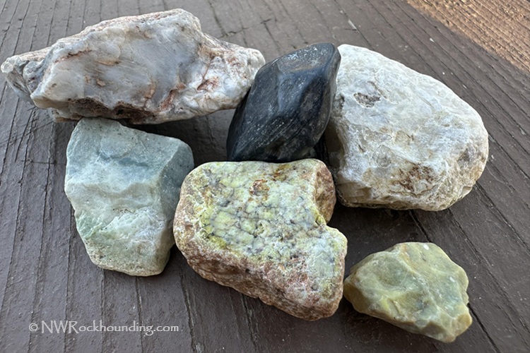
Cottonwood Creek, a high desert destination in Malheur County, Eastern Oregon, lies 32 miles southwest of Vale and 43 miles east of Juntura. The creek’s extensive gravel deposits offer opportunities to find jasper, picture jasper, agate, quartz, obsidian, and apache tears.
Shifting river channels and ancient lake deposits have shaped the area, leaving behind large gravel beds. Erosion and changing water levels continue to expose a diverse mix of rocks and minerals, making this a rewarding site for rockhounds.
To reach the area, follow Crowley Road, a dirt route south of Highway 20, leading to the creek. The first site, located at the bridge, is 9.5 miles from the highway.
A high-clearance 4WD vehicle is recommended, and travel is not advised during wet conditions. The area is remote, with limited services and cell coverage, so plan accordingly.
Cottonwood Creek Rockhounding
The best time to visit is during the dry season when the road is passable, and water levels drop, exposing large gravel deposits. Crowley Road meets Cottonwood Creek at the bridge, where searching can begin.
The next site is 2.7 miles away. Both locations yield picture jasper, jasper, agate, obsidian, and apache tears. Occasionally, pieces of quartz and petrified wood can be found.
Jasper is the most abundant find, appearing in red, brown, green, and yellow varieties. Picture jasper typically features light brown and green hues. Agate is scarce, with most pieces being clear. Large apache tears can also be found, with some reaching the size of a golf ball.
Surface collecting is the primary method here, though a geology pick can be useful.
Know Before You Go
Here are a few things you should keep in mind before heading to Cottonwood Creek:
- 4WD Vehicle: A high-clearance 4WD is highly recommended. The roads are rough and can be impassable after rain.
- Remote Location: There are no services (gas stations, drinking water, or stores) within 20-30 miles of the site. Ensure your vehicle is fully fueled, and bring plenty of water and supplies. Cell service is spotty or non-existent.
- Desert Wildlife: Watch out for rattlesnakes—they are common in this area.
Plan your trip. Bring enough water, sunscreen, and supplies to stay safe in the heat.
Familiarize yourself with desert safety practices to better prepare for the unique challenges of this remote and stunning landscape.
Beyond the Rocks: Exploring the Area
This area is remote with just few attractions nearby.
For those looking to explore further, another great collecting site, Scull Spring, is located 23 miles away. Additional rockhounding locations in the region include Twin Springs, Negro Rock, and Haystack sites in the Vale-Nyssa Area.
If you like bathing in natural mineral water, Crystal Crane Hot Springs near Burns offers a rustic resort experience with camping and various lodging options for those who enjoy soaking in natural mineral water.

Cottonwood Creek | Facts
Material: Jasper, picture jasper, agate, quartz, obsidian, and apache tears
Tools: Geology pick
Land type: High Desert
Best time to visit: May through October
Land manager: Bureau of Land Management (BLM)
Fees: None
Location: 32 miles southwest of Vale • Oregon • USA
Road access: A high-clearance 4WD vehicle is recommended
Elevation: 3,200 ft (975 m)
Places to Stay near Cottonwood Creek
Primitive camping is allowed on most BLM-managed public lands.
For lodging, options are available 50 miles northeast in Ontario, Oregon, or 70 miles east in Homedale, Idaho.
Affordable vacation rentals for short and long term stay in Ontario, OR
Affordable vacation rentals for short and long term stay in Homedale, ID
You May Also Like


Directions to Cottonwood Creek
From Juntura,
- Travel east for about 43 miles to Crowley Road (milepost 223.1)
- Turn right (south) onto Crowley Road and follow it for about 9.5 miles to the bridge (Site 1)
- Continue 2.7 miles to Site 2.
GPS (Site 1): N 43°44.407' W 117°40.421' | 43.74, -117.6737
GPS (Site 2): N 43°42.614' W 117°42.155' | 43.7102, -117.7026
Comments are closed, but trackbacks and pingbacks are open.