
The areas along the TransAmerica Trail in southwestern Idaho, 30 miles south of Mountain Home, are part of the Bruneau-Owyhee canyon region, which formed mainly during the Miocene to early Pliocene, about 17-5 million years ago.
During this time, repeated volcanic eruptions spread thick lava flows across southern Idaho, creating layers of basalt and rhyolite as the molten rock cooled and hardened.
Over time, fractures formed in the volcanic rocks, creating pathways for silica-rich groundwater to circulate through cracks and porous zones in the lava flows.
As time passed, groundwater slowly moved through the layers of volcanic rock.
Minerals then formed as dissolved silica hardened. These included fine-grained silica minerals such as agate and jasper, as well as crystalline quartz. These minerals often fill cracks and cavities inside the lava flows.
In some places, volcanic ash and groundwater helped preserve buried plant material. Over time, this material was replaced by silica and turned into petrified wood.
Later, the land was stretched and broken by tectonic forces. Erosion from the Bruneau River system cut deep canyons into the hardened lava flows and ash deposits, exposing the mineral-rich layers at the surface.
Today, the area has rugged canyon walls and volcanic outcrops where jasper, quartz, and petrified wood can be found.
Bruneau River Canyon Rockhounding
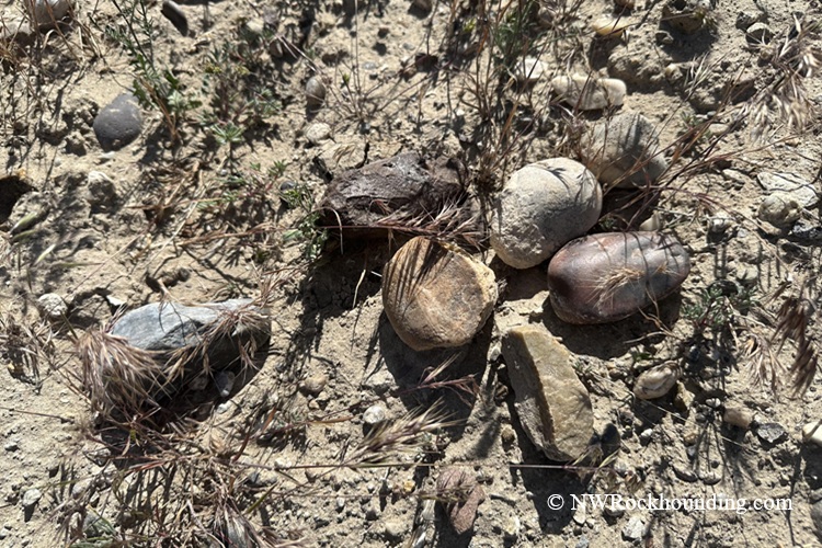
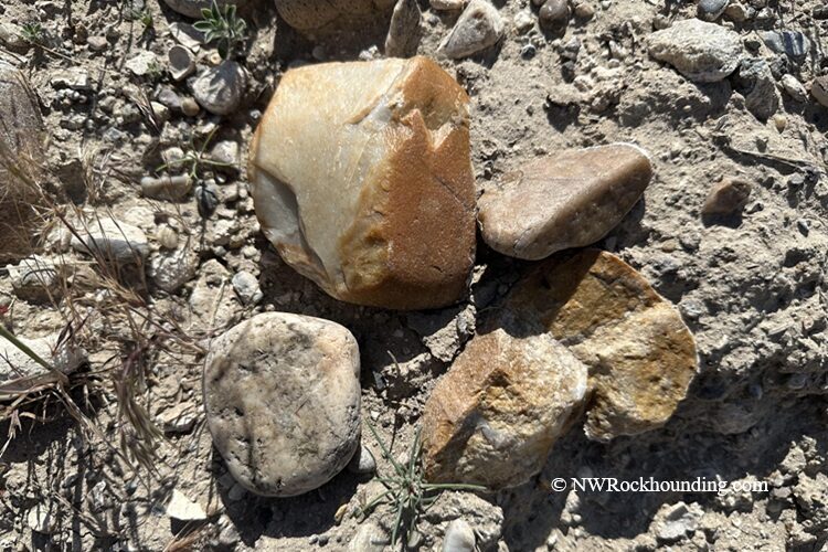
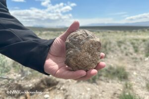
Jasper is the standout material here. Some specimens display stunning patterns with tiny bubbles and spheres in endless variety. The surrounding public land still produces excellent jasper, especially in nearby gulches and along road cuts.
Petrified wood turns up just about everywhere. Side roads branching off the main route regularly yield nice specimens. Petrified limb casts have also been found in the gulches near the main sites.
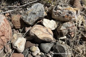
Rounded river rock fills the road cuts and gravel pits along the route. Many plain-looking stones reveal wild patterns and colors when cut open. Look for larger pieces you could slab at home.
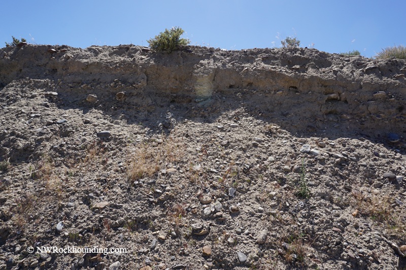
As soon as you clear the ranches in the bottomland and the road begins to climb, the landscape changes. Exposed gravel beds and road cuts full of rounded stones appear on both sides. That's your signal, you've entered collecting territory.
Site 1 sits about 8.6 miles from Bruneau, off to the left on a dirt road. A nearby gulch is especially worth checking.
Site 2 is roughly 9.4 miles from Bruneau, on the right side of the road. This site produces jasper, petrified wood, and limb casts.
Site 3 is a large gravel pit about 10.7 miles from Bruneau, on the left. Surface collecting yield interesting material, including naturally rounded river rocks.
Bring a geology pick, a sturdy bucket, plenty of water, and sun protection. There are no services between Mountain Home and the collecting sites.
Also, bring a spare tire since the gravel roads are rough and full of sharp rocks.
Best time to collect: Late spring and fall offer the most comfortable conditions. Summer temperatures often exceed 100°F, and there is no shade available. Aim for May through early June or September through October.
Things to Do Near Bruneau River Canyon: Beyond the Rocks
Bruneau Canyon Scenic Overlook sits along the route to the collecting sites. The drop is dramatic, with over 800 feet straight down in places. Colorful layers of volcanic rock line the canyon walls, and the river threads through the bottom like a thin blue ribbon.
Bruneau Dunes State Park along ID 51 between Mountain Home and Bruneau is worth a visit, too. It features the tallest single-structured sand dune in North America, rising about 470 feet. The park offers developed campsites, hiking trails, fishing lakes, and an observatory with public stargazing programs.
The Owyhee Uplands Back Country Byway winds through remote desert country south of Bruneau with dramatic canyon views and access to some of Idaho's most isolated landscapes.
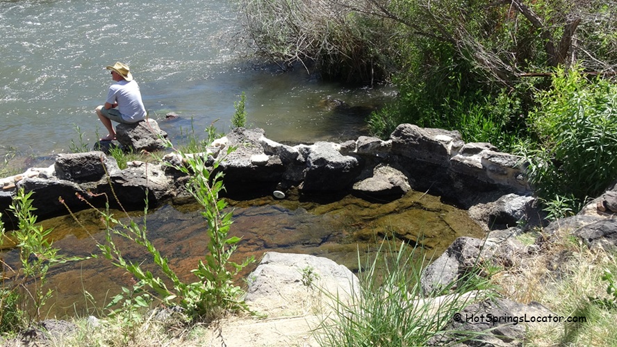
Lower Indian Bathtub Hot Springs is a natural soaking pool tucked in a remote canyon along the Bruneau River. The water stays at a steady 102°F year-round. Reaching it requires a rugged drive and a short, steep 0.15-mile hike from the canyon rim. High-clearance 4WD is recommended for the final stretch. No facilities, so pack out everything you bring.
Bruneau River Canyon Rockhounding | Facts
Material: Jasper, agate, quartz, petrified wood, petrified limb casts
Tools: Geology pick, bucket, water, sun protection
Land type: High-desert hills, gulches, gravel pits, road cuts
Best time to visit: Late spring and fall
Land manager: Bureau of Land Management (BLM-Bruneau)
Fees: None
Location: Owyhee County • Idaho • USA
Road access: Any vehicle (gravel roads, so bring a spare tire)
Bruneau River Canyon Camping and Lodging
Primitive camping is available on open BLM land near the collecting sites. It's free and completely wild. Bring everything you need, including water.
Bruneau Dunes State Park offers developed campsites with fire rings, picnic tables, restrooms, and trail access. It sits roughly halfway between Mountain Home and Bruneau along ID 51. Reservations are recommended during summer weekends.
For more comfortable accommodations, Mountain Home is about 30 miles north with motels, restaurants, and RV parks.
You May Also Like


Bruneau River Canyon Access and Directions
From Mountain Home,
- Head south on ID 51 toward the town of Bruneau
- Just as you enter Bruneau, turn left onto Hot Springs Road
- After 8.2 miles the main road turns left and becomes Clover 3 Creek Road.
Site 1 is about 8.6 miles from Bruneau, off to the left
Site 2 is about 9.4 miles from Bruneau, on the right
Site 3 is a large gravel pit about 10.7 miles from Bruneau, on the left
Site 1: N 42°47.132' W 115°42.248' | 42.786, -115.704