

Glass Butte and Little Glass Butte, located off Highway 20 between mileposts 75 and 81 (57 miles west of Burns and 78 miles east of Bend), are among Oregon's prime destinations for high-quality obsidian. These two sites, only half a mile apart, cover a 6,000-acre area managed by the Bureau of Land Management (BLM) and are renowned for a remarkable variety of volcanic glass.
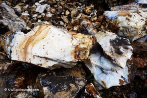
The variety of obsidian you can find here is impressive, including prized gold sheen, mahogany, and fire sheen, among others. The surrounding high desert, with its volcanic peaks and sagebrush-covered hills, offers a scenic backdrop to explore.
Collectors can take up to 250 pounds or a trunk load of obsidian for personal use without a permit.
Glass Butte Rockhounding
Glass Butte, the larger of the two buttes, is the primary spot for finding obsidian in the area. Here, you’ll find a wide range of obsidian types, including black, gold sheen, silver sheen, rainbow sheen, mahogany, midnight lace, and fire sheen. Surface collecting is common, but if you dig with a pick or shovel, you’ll have a chance at uncovering larger, more valuable specimens.
Little Glass Butte, situated just east of Glass Butte, offers similar obsidian varieties and is typically less crowded. This area features deeper pits and an additional type of volcanic glass known as leopard skin obsidian, prized for its unique patterns.
Many collectors choose to dig shallow pits here, especially where larger pits already exist. Tools like a rock pick, shovel, or hammer help break through the topsoil to access larger fragments.
Be mindful to fill in any pits once you're done, helping preserve the area’s landscape.

Know Before You Go
There are a few things to keep in mind when you head out to the Buttes:
- Sharp Edges: Obsidian has razor-sharp edges, so gloves and eye protection are essential when handling or breaking it.
- Vehicle Access: The roads to the area are rugged and uneven, so a 4WD vehicle is highly recommended. Pack fix-a-flat or a spare tire, as obsidian shards on the ground can easily puncture tires.
- Desert Conditions: The buttes are in a dry, open desert with very little shade. Bring plenty of water, wear sunscreen, and take breaks as needed to stay cool.
- Tools: Useful tools include a rock hammer, geology pick, pry bar, and shovel for digging and extracting larger obsidian pieces.
- Primitive Camping: Primitive camping is permitted on BLM land, but be prepared with enough water, food, and supplies, as services are limited in this remote area.

Beyond the Rocks: Exploring the Area
The high desert environment provides stunning views, especially at sunset, and the isolation of the area makes it a peaceful retreat from busier rockhounding destinations.
In addition to rockhounding, the area is great for hiking, wildlife watching, and primitive camping.

Glass Butte | Facts
Material: Obsidian (Gold, Silver, Fire Sheen, Rainbow, Mahogany, Midnight Lace, etc.)
Tools: Rock hammer, geology pick, shovel, and pry bar
Land type: High desert
Best time to visit: May through October
Land manager: Bureau of Land Management (BLM)
Fees: None
Location: 57 miles west of Burns • Oregon • USA
Road access: A high-clearance 4WD vehicle is recommended
Elevation: 4,900-6,100 ft (1,494-1,829 m)
Places to Stay Near Glass Butte
Primitive camping is permitted on BLM land.
You can book a stay in Burns, 57 miles west, and Bend, 78 miles east, if you want more comfortable accommodation.
Affordable vacation rentals for short and long term stay in Burns
You May Also Like


Glass Butte and Little Glass Butte Directions
From Bend,
- Travel east on Highway US-20 for about 70 miles
- Turn right(south) onto dirt gravel road between mileposts 81 and 82.