

Located about 4 miles south of Yachats and 1 mile south of Cape Perpetua Marine Garden, Neptune Beach stretches roughly 0.5 miles from Gwynn Creek to the southern boundary of Neptune State Park.
The beach features a mix of sand, cobbles, and volcanic basalt, making it a popular spot for rockhounding and tidepool exploration.
It is divided into Neptune North and Neptune South by Cummins Creek and is part of the the Neptune State Scenic Area.
Nearby coastal towns such as Yachats and Florence offer a range of amenities, including lodging, dining, and local attractions.
Neptune North
Neptune North is a less developed area with a small pullout parking and a gravel trail leading to the shore.
Neptune North is a less developed section with a small pullout parking area and a gravel trail leading to the shore. The cove-shaped basalt and sand beach is a smaller version of Cook's Chasm. Visitors may occasionally see spouting horns as seawater is forced through basalt crevices and erupts into the air.
Neptune South - Neptune State Park
The southern section, Neptune State Park, is more developed and offers amenities such as a grassy lawn, picnic tables, and restrooms. Visitors can enjoy wide Pacific views, with waves breaking along the shore and Cummins Creek flowing into the ocean.
Note: Neptune Beach is part of the Cape Perpetua Marine Reserve. Fishing and the collection of invertebrates, seaweeds, or any wildlife are strictly prohibited. Please refer to the Oregon Marine Reserves Harvest Restrictions for more information.

Neptune Beach Rockhounding
Neptune Beach is part of a productive rockhounding coastline that extends from Yachats to Carl G. Washburne Memorial State Park.
Within this area, you can uncover agates (including carnelian and sagenitic varieties), jasper, petrified wood, shells, sea glass, and other interesting materials. The most productive areas are around the mouth of Cummins Creek and along gravel bars, especially during low tide after winter storms.
The best rockhounding season is typically from November through April, when storms and king tides help expose new material by removing surface layers of sand and gravel.
During winter, when creek flow is stronger, crossings may be unsafe. If time is limited, it is best to begin exploration at Neptune State Park (southern access).
Because Neptune Beach is within a marine reserve, only surface collecting is allowed. Digging and the use of tools are prohibited, except for a beach scoop, which is generally acceptable.
🔵 A permit is required to collect vertebrate fossils.
🟡 Visitors should be cautious of changing tides, rip currents, driftwood, and sneaker waves. Never turn your back on the ocean.

Things to Do at Neptune Beach: Exploring the Area
Neptune State Park and the surrounding area offer multiple hiking trails.
The Cummins Ridge Trail is a 5.8-mile one-way route through the 9,300-acre Cummins Creek Wilderness, featuring the only old-growth Sitka spruce forest on the Oregon Coast. This challenging trail is rated as difficult.
There are two trailheads, East and West. For a one-way hike, many hikers start at the East Trailhead and use a car shuttle to complete the easier downhill route.
The Cape Perpetua Visitor Center provides maps and information for the Cummins Ridge Trail and other nearby trails.
The rocky shore of Neptune Beach is also excellent for tidepool exploration. Visit during low tide to observe marine life and coastal plants in natural tidepools.

Thor’s Well, also known as the ‘Gate to Hell,’ is a 20-foot-deep sea cave located at Cook's Chasm. Ocean waves have eroded the top of the basalt, creating a sinkhole that forces water to surge and shoot upward during strong wave activity.
The best time to witness Thor’s Well in action is during high tide and storm conditions. The most dramatic displays typically occur from about one hour before to one hour after high tide.
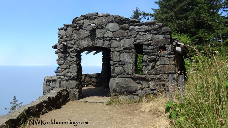
Cape Perpetua Scenic Area encompasses 2,700 acres of old-growth forest within the Siuslaw National Forest. The Visitor Center features exhibits and short films about the region’s natural and cultural history. Nearby, the Cape Perpetua West Shelter, built in the early 1930s by the U.S. Forest Service, sits at 800 feet (240 meters) above sea level. On clear days, it offers panoramic views of up to 70 miles of coastline and 37 miles out to sea.
The area is popular for hiking, wildlife viewing, fishing, picnicking, and outdoor photography.
Neptune Beach | Facts
Material: Agate, jasper, and petrified wood
Tools: Sand Dipper Square Scoop
Land type: Rocky and sandy beach
Best time to visit: Year-round, most productive between November and April
Land manager: Oregon State Parks
Fees: None
Location: 4 miles south of Yachats • Oregon • USA
Road access: Any vehicle
Places to Stay Near Neptune Beach
You May Also Like


Neptune Beach Directions
From Yachats,
- Follow 3.8 miles south on Highway 101 to Neptune North on the right
- Continue 0.3 miles south to Neptune State Park.
Phone: 541-547-3416
stateparks.oregon.gov