
Located about 35 miles northeast of Burns, North Beede Reservoir is a popular destination for rockhounding. This rugged sagebrush-covered landscape contains agate, jasper, petrified wood, and fossil leaves.
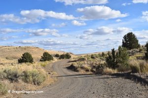
The collecting area, managed by the Bureau of Land Management (BLM), begins just off the highway and extends northeast for approximately 2.7 miles. Beyond this point lies private land where collecting is prohibited.
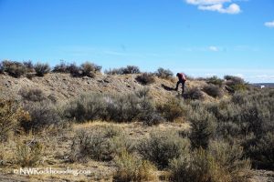
Some parts of the North Beede area are easily accessible, such as Site 1, while others require a high-clearance 4WD vehicle or a longer hike.
To explore additional collecting areas, you'll need to cross the creek at Site 2, so be prepared for rough road conditions. Areas farther from the highway may offer a greater variety of specimens.
North Beede Reservoir Rockhounding
The area north of the reservoir contains a variety of collectible rocks and minerals.
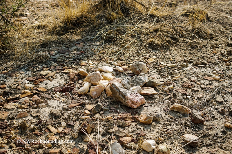
Specimens can be found on the flatlands and hillsides throughout the collecting area. Dry washes and hillside slopes are often productive because seasonal water flow can expose previously buried material.
During the dry season, the hard ground can make collecting more difficult. A rock hammer, geology pick, and chisel can be useful tools for locating and extracting specimens.
North Beede Reservoir Rocks
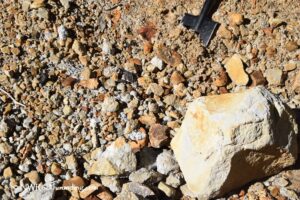
- Agate: Gray, white, and clear varieties.
- Plume Agate: Usually white and yellow, with occasional pink, blue, or yellow hues.
- Jasper: Red, yellow, and brown varieties.
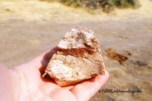
- Petrified Wood: Small pieces, often in red or brown shades.
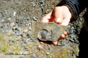
- Fossil Leaves: Found embedded in chalky white rock.

Collecting Sites
Site 1
For those without a high-clearance 4WD vehicle, Site 1 offers the easiest access. Park near the highway or drive about 0.2 miles to the fork in the road. Explore the surrounding flats and sagebrush-covered terrain, where small to medium-sized pieces of agate, jasper, and petrified wood can often be found on the surface.
Site 2
For Site 2, take the left road at the fork and travel approximately 0.7 miles. If conditions allow, cross the creek to reach the white cliffs. This area is known for fossil leaf specimens. Bring tools to split rocks carefully and examine potential fossil-bearing material.
Other Sites
Continue past Site 2 for another 1.8 miles to the BLM boundary. Areas farther from the highway may contain larger specimens. Search dry washes, hillsides, and gullies for agate, jasper, petrified wood, and other material.

Know Before You Go: The North Beede Reservoir area is remote and rugged, so preparation is important.
- Vehicle Requirements: The road is rough and may become muddy after rain. A high-clearance 4WD vehicle is recommended.
- Lack of Services: There are no nearby gas stations, food services, or water sources. Bring all necessary supplies, including a spare tire, sunscreen, and plenty of water.
- Wildlife Precautions: Watch for rattlesnakes and other desert wildlife. Wear sturdy boots while exploring.
- Road Conditions: If the road appears muddy or impassable, park and continue on foot.
- Personal Safety: Cell service is limited. Inform someone of your travel plans and consider carrying a satellite communication device.
- Safety Preparations: Familiarize yourself with desert safety practices to better prepare for the unique challenges of this remote area.

Things to Do Near North Beede Reservoir: Exploring the Area
In addition to rockhounding, the area surrounding North Beede Reservoir offers opportunities for wildlife viewing and hiking in Oregon's high desert.
The nearby Beulah Reservoir provides opportunities for fishing, camping, and additional rockhounding.
For those interested in hot springs, Crystal Crane Hot Springs is located south of the collecting area near Burns. Farther southeast, Alvord Hot Springs offers soaking pools near the edge of the Alvord Desert.
The Alvord Desert region also contains several geothermal features. Nearby areas such as Mickey Hot Springs and Borax Lake Hot Springs include hot springs, steam vents, and other geothermal activity.
On the opposite side of the highway, approximately 30 to 40 miles away along Stinking Creek Road, several additional rockhounding locations attract collectors. Warm Springs Reservoir is known for plume agate, while the Clear Creek area is a source of Stinking Water petrified wood.
The Beulah Reservoir, 40 miles northeast, has even more adventures, including rockhounding, camping, and fishing.
North Beede Reservoir | Facts
Material: Agate, plume agate, jasper, petrified wood, and fossil leaves
Tools: Geology pick, hammer, and chisel
Land type: High desert
Best time to visit: Late spring to summer
Land manager: Bureau of Land Management (BLM)
Fees: None
Location: 35 miles northeast of Burns • Oregon • USA
Road access: A high-clearance 4WD vehicle is recommended
Elevation: 3,658-3,840 ft (1,115-1,170 m)
Places to Stay Near North Beede Reservoir
Camping is allowed on BLM land, and primitive camping is available at Warm Springs Reservoir.
If you prefer a more comfortable stay, the nearest lodging is in Hines and Burns.
You May Also Like


North Beede Reservoir Directions
From Burns,
- Take U.S. Highway 20 and follow it for 35 miles
- Look for an unmarked dirt road between mileposts 166 and 167
- Turn onto the dirt road and travel about 0.2 miles to a fence. Go through the fence and close it behind you
- Park at the fork in the road or continue exploring if your vehicle can handle rough terrain.
GPS (Site 1): N 43°45.287' W 118°28.527' | 43.7548, -118.47545
GPS (Site 2): N 43°45.699' W 118°29.106' | 43.7611, -118.485