

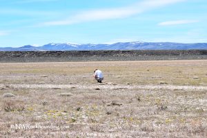
Pike Creek Canyon is a scenic destination sitting on the eastern slope of Steens Mountain at the edge of Alvord Desert, the largest dry lakebed in Oregon. This area features stunning high desert landscape and amazing geology.
Pike Creek runs year-round, creating a lush, shady oasis in the dry high-desert region. This creek provides a stark contrast to the surrounding arid landscape and supports a diverse ecosystem of plants and wildlife. When Pike Creek merges into the Alvord Desert, it dries up and, finally, disappears.
A free parking area near Fields-Denio Road is accessible by any passenger car. From this parking area, it’s a 0.5-mile hike to the camp and trailhead. Those with high-clearance vehicles can drive a portion of the road, but it is not recommended to drive all the way to the trailhead due to the deteriorating condition of the public road. The road is increasingly bumpy and strewn with large boulders, making a U-turn challenging without damaging the vehicle.

Pike Creek Rockhounding
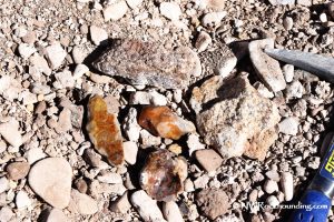
Pike Creek Canyon is a prime spot for rockhounding, offering an opportunity to collect a variety of interesting and valuable specimens including jasper, agate, obsidian, petrified wood, and sea fossils.
The agate and jasper can be found in shades of gray, beige, yellowish, and purple-reddish hues. Moss agate varieties are also present. Obsidian, scattered throughout the area, is predominantly black.
The collecting area is quite extensive here. You can search mountain slopes, creek beds, and dry washes.

The highlight of rockhounding at Pike Creek is a chance to find thundereggs filled with agate and/or quartz crystal. Thundereggs are very scarce here but still, you can find some along the creek and approximately a mile up along the trail that starts from the camping area. Geology pick might be useful during your hunt for collectibles.
While rockhounding, it’s important to note the proximity of the Steens Mountain Wilderness. Digging is not allowed within wilderness areas, but surface collecting is permitted.

Beyond the Rocks: Exploring the Area
Besides rockhounding, this area surrounded by scenic wild nature provides an opportunity to enjoy a variety of outdoor activities including a hiking on the eastern slope of Steens Mountain, camping, soaking in rejuvenating hot springs, and nature viewing.
Located two miles away from Pike Creek Trailhead, Alvord Hot Springs is a geothermal oasis in the middle of the high desert offering rejuvenating soaking in the rich-mineral water.
Other geothermal areas of the Alvord Basin, Mickey Hot Springs and Borax Lake Hot Springs are geological phenomena of southeastern Oregon. Both hot springs features scalding temperatures and colorful thermal pools. So, no soaking is available.
Pike Creek Trail is a 5.6 miles out-and-back route running up the canyon along Pike Creek. The trailhead begins at a colorful huge boulder that hosts a juniper tree sprouting from it. The first 1.4 miles of the trail is an established old mining track leading to an abandoned uranium mine shaft.
Pike Creek Canyon | Facts
Material: Jasper, agate, thundereggs, obsidian, fossils, and petrified wood
Tools: Geology pick
Land type: Mountains and high desert
Best time to visit: From May to October
Land manager: Bureau of Land Management, partially private
Fees: None on public land
Location: 25 miles north of Fields • Oregon • USA
Road access: A high-clearance 4WD vehicle is suggested
Elevation: 4,300 ft (1,310 m)
Places to Stay near Pike Creek Canyon
Camping is permitted at Pike Creek with cottonwoods and massive boulders offering shelter and protection. Do not cut any trees for firewood or camping. It is prohibited and endangers the high desert ecosystem due to the scarcity of trees.
Other primitive camping sites are available at Mann Lake, Alvord Playa, and Alvord Hot Springs.
Comfortable accommodations can be found the Hines-Burns Area, 100 miles away.
Lodging in the Hines-Burns Area
Affordable vacation rentals for short and long term stay in the Hines-Burns Area
You May Also Like


Pike Creek Canyon Directions & Contacts
From Burns,
- Head 65 miles southeast on Highway 78 to Folly Farm Road
- Turn right onto Folly Farm Road and follow 2.5 miles, the road becomes Fields-Denio Road
- Continue 37 miles on Fields-Denio Road towards Fields (the part of the road is gravel).
Phone: 541-947-2151
fs.usda.gov
Parking at Fields-Denio Road: N 42°34.432' W 118°31.495' | 42.571006, -118.522187