Even with great maps and guidebooks, a hiking GPS is essential for remote adventures. Whether you're driving to a trailhead or hiking to a hidden spot, a reliable GPS helps you save time and stay on track.
It's not just about reaching your destination—it's about finding your way back safely.

A dependable GPS gives you peace of mind and makes your trip more enjoyable. Invest in a good GPS to simplify your adventure and explore with confidence.

Have a Dedicated GPS Unit

Separate GPS units like Garmin are generally more reliable in remote locations than the GPS units in smartphones. However, these devices require manual map updates to stay accurate. Without regular updates, you might encounter closed roads or miss better routes.

Thankfully, manufacturers provide detailed instructions for updating maps on their websites and in owner manuals. Be sure to complete these updates before your trip. If you plan to explore on foot, consider a handheld GPS unit in addition to your smartphone for greater reliability and precision.

Understand GPS Coordinates

Check the format of the GPS coordinates you’re using, as maps and guides may use different formats. Make sure the format matches your GPS device settings to avoid confusion. Test it at home before your trip to ensure everything works smoothly.


The Best Hiking GPS Navigator Review

We tested these best GPS hiking navigators, along with input from thousands of users, to determine the top performers. Here’s our top pick based on price, features, and performance.

Garmin Foretrex 801 Review - The Best Value GPS Navigator

Garmin Foretrex 801 combines premium features with exceptional value—offering performance comparable to high-end navigators at the cost of a dinner for two.

This is the wrist-mounted device integrates Galileo and GLONASS navigation system all in one.

Plus, it has useful features like smart notifications. You can receive texts, emails, and weather notifications (like a storm warning). It is also impact, water, and heat resistant and built to last.

The Best Value GPS Hiking Navigator: Garmin Foretrex 801

Garmin Foretrex 801 is a wrist-mounted, durable mil-spec device with multi-satellite systems, including GPS, GLONASS, and Galileo.

  • Advanced Sensors: 3-axis compass, 3-axis accelerometer, and barometric altimeter
  • Smart notifications: Receive texts, emails, and alerts
  • InReach Compatibility: Pair it with your compatible inReach satellite communicator
  • Jumpmaster Mode: Use jumpmaster mode to calculate high-altitude release points (if you jump out of the airplane to reach your next rockhounding site)
  • Durability: Withstand high temperature, shock, and water exposure
  • Extended Battery Life: Over 100 hours of run time

If you make a purchase via our links, Northwest Rockhounding earns a commission at no additional cost to you

Pros:

  • Reliable
  • Affordable
  • Has features of more expensive models

Cons:

  • Black-and-white display
  • Takes some time to get used to if you have never worked with the Garmin Foretrex series before

Garmin GPSMAP 66i Review - The Best Hiking GPS Satellite Phone Combo

After 15 years of using various GPSs, our team found Garmin GPSMAP 66i to be the best choice.

Here is our quick list of the device benefits.

Garmin GPSMAP 66i is not just a hiking GPS navigator; it's a complete navigational computer combined with a satellite phone.

This is the most important feature because a satellite phone is a critical piece of gear during challenging trips. It can literally save your life.

You get all the advanced GPS navigator features like preloaded TOPO map and many others typical for high-end GPS navigators.

The inReach subscription lets you trigger the SOS to the GEOS 24/7 emergency response team in case of an emergency. It also enables LiveTrack location with two-way messaging.

Considering the price of the satellite phone, you can easily save $1000 or more if you buy Garmin GPSMAP 66i.

The battery lasts 35 hours, and you can extend it up to 200 hours in expedition mode. This way, if you are out for a longer trip, you can make the navigator function for a while on one charge!

The Best Hiking GPS Satellite Phone Combo: Garmin GPSMAP 66i


Garmin GPSMAP 66i is the best navigator and satellite phone combo with a ton of useful features.

  • Hiking GPS navigator with features of more expensive models
  • Uses both GPS and Galileo systems for accurate navigation
  • Cellular connectivity to access weather forecasts and geocaching live
  • Built-in satellite phone to send messages and activate SOS signal
  • Rechargeable lithium battery with up to 35 hours in 10-minute tracking mode

If you make a purchase via our links, Northwest Rockhounding earns a commission at no additional cost to you

Pros:

  • The best overall GPS navigator
  • Built-in satellite phone
  • Long battery life

Cons:

  • You still need to purchase a satellite subscription like on any satellite phone

Garmin Fenix 7 Solar Review - The Best GPS Smartwatch

Garmin Fenix 7 Solar is the best GPS (GLONASS and Galileo, too) smartwatch for athletes and adventurers.

The smartwatch does what it should: it GPSes you around (if that is even a word?). But what sets it apart are advanced features for outdoor enthusiasts, hikers, surfers, cyclists, and other athletes.

In fact, it has features I never knew I would need. But now I do.

It's like the Leatherman and Tesla of smartwatches, replacing a backpack full of tools on your wrist.

The Fenix 7 analyzes the data and gives personalized recommendations for your goals (fat loss, triathlon prep, etc.)

It measures various vitals, including:

  • Heart Rate
  • Stress Levels
  • Sleeping Patterns
  • VO2 Max

And more to give you accurate health updates.

The "Body Battery" indicator is a unique feature I haven't seen anywhere else. It shows how much energy you have left to finish the day—and it's amazingly accurate.

Oh, and it's solar-powered. No more fiddling with charging cables at a random gas station in the middle of nowhere!

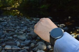
The Best GPS Smartwatch: Garmin Fenix 7 Solar

If Inspector Gadget was a rockhound, hiker, triathlete, gym bro, cyclist, and health enthusiast all in one, the Garmin Fenix 7 Solar would be on his wrist.

The smartwatch gives you real-time stamina tracking, comprehensive training status updates, and advanced performance metrics, and it has over 30 built-in sports apps. Useful ones, not bloatware.

Garmin Fenix 7 Solar is a Leatherman and Tesla of smartwatches. It replaces a bag full of tools and devices, all on your wrist.

In addition to navigation, you get:

  • Health and Wellness Monitor
  • Music Player
  • Built-In Sports Apps
  • Flashlight
  • 3-axis Compass, Gyroscope, and Barometric Altimeter


If you make a purchase via our links, Northwest Rockhounding earns a commission at no additional cost to you

Pros:

  • Replaces A LOT of devices
  • Garmin quality and navigation accuracy
  • Very accurate health measurements

Cons:

  • Pricey
  • Slightly heavier than an average watch

Potential GPS Unit Issues

GPS navigation systems, including Google Maps, can be inaccurate. Especially in remote or backcountry areas. Several factors contribute to these errors:

Satellite Signal Strength: In remote locations, when the GPS satellite signals are weaker, accuracy can be reduced.

Terrain and Obstacles: Natural features such as mountains, dense forests, or tall buildings can obstruct GPS signals and cause inaccuracies in location data.

Map Data Quality: The accuracy of the map data is more important than it seems. In some cases, map data for backcountry areas may not be as detailed or up-to-date as urban areas.

Device Limitations: The quality of the GPS receiver in the device also matters. Some devices may have more accurate GPS modules than others.

Weather Conditions: Heavy rain or dense clouds can affect the accuracy of GPS signals.


How to Prevent GPS Issues

1) Use dedicated GPS devices designed for outdoor activities (as opposed to driving units), as they often have better accuracy in challenging environments.

2) Download offline maps for the specific area you plan to explore, reducing reliance on real-time GPS data.

3) Cross-reference GPS navigation with other navigational tools like compasses and physical maps.

4) If you have a specific issue with Google Maps or another navigation service, providing feedback to the service provider can help improve the accuracy of their mapping data in the future.


Leave a Reply

Your email address will not be published. Required fields are marked *