

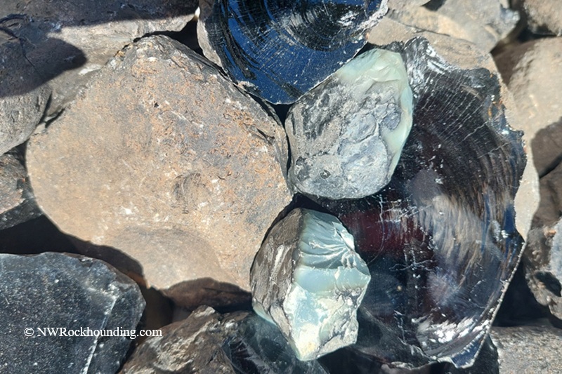
The area northwest of Highway 20 near Hines and Burns was once known for its diverse obsidian deposits, including black, green, greenish-blue, red, and snowflake varieties. These deposits formed during episodes of volcanic activity roughly 5 to 20 million years ago, when rhyolitic lava cooled rapidly and hardened into volcanic glass.
Today, much of the surrounding land is privately owned. However, a small section near Mud Ridge remains open to public collecting on land managed by the Bureau of Land Management (BLM).
The BLM property begins about 9 miles north of Highway 20 at a gated entrance. According to signs posted at the site, the access road may be closed during winter and early spring because of seasonal conditions. It is a good idea to contact the BLM Burns District Office before your trip to verify access.
Mud Ridge at Hines Rockhounding
The BLM-managed collecting area extends approximately 6 miles beyond the gate. The GPS coordinates below mark a recommended starting point, though obsidian can be found throughout the area.
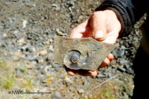
Surface collecting is often productive. Obsidian fragments are commonly scattered across the sagebrush flats, hillsides, and dry washes. While black obsidian is the most abundant variety, patient collectors may also find green, greenish-blue, red, and snowflake obsidian.
A geology pick can be useful for uncovering partially buried material, but any holes created during collecting should be filled before leaving.
As always, practice responsible rockhounding by respecting private property boundaries, packing out trash, and following BLM regulations.

Beyond the Rocks: Exploring the Area
There are several excellent rockhounding sites near Burns, including the obsidian deposits at Glass Butte. For those seeking plume agates, the areas around Warm Springs Reservoir and North Beede Reservoir provide great opportunities. Unique oolitic agate can also be found 25 miles from Hines, at the ancient lakebed in Harney Basin.
The vast Alvord Desert offers a striking landscape for exploration. For geothermal enthusiasts, Borax Lake Hot Springs and Mickey Hot Springs, are fascinating sites to observe geothermal wonders, though they are not suitable for soaking due to the extreme temperatures.
If you’re looking to unwind after a day of rockhounding, both Crystal Crane Hot Springs and Alvord Hot Springs offer overnight accommodations and the chance to soak in mineral-rich waters.
Mud Ridge | Facts
Material: Obsidian
Tools: Geology pick
Land type: High desert
Best time to visit: Late spring through early fall
Land manager: Bureau of Land Management (BLM)
Fees: None
Location: 10 miles east of Hines • Oregon • USA
Road access: A high-clearance 4WD vehicle is recommended
Elevation: 4,650 ft (1,420 m)
Places to Stay near Mud Ridge
No camping is allowed at this site.
Various types of accommodations are available in Burns and Hines.
Affordable vacation rentals for short and long-term stays near Burns
You May Also Like


Directions to Mud Ridge
From Highway 20 in Burns,
- Take N Foley Drive and travel west for 1.3 miles to Radar Base Road
- Turn left onto Radar Base Road and continue for 2.6 miles to the BLM gate on Skull Creek Road.
From Highway 20 in Hines,
- Turn west onto Hines Lodging Road (National Forest Road 47) at the southern end of Hines
- Travel 4.5 miles to a gravel road on the right
- Turn right, and after 0.1 miles, bear left onto Radar Road
- Continue for about 3.3 miles to the gate.
From the gate,
- Travel on Skull Creek Road 1.7 miles west, then turn right and continue 1.1 miles.
This is BLM-managed land, where you can begin your search and explore along the road for the next 3 miles.
GPS (The BLM gate): N 43°36.491' W 119°06.449' | 43.608183, -119.107483
Comments are closed, but trackbacks and pingbacks are open.