

The Chetco River flows for 56 miles from its tributaries in the Klamath Mountains. It runs through the remote southwestern Oregon before reaching the Pacific Ocean at Brookings.
The headwaters and 44 miles of the upper river are designated as wild and scenic. This remote and secluded section of the Chetco features multiple rare plants, outstanding water quality, and many Class III, IV, and IV+ rapids.
The 11 miles of the lower section of the river are recreational, with multiple easily accessible spots for rockhounding, fishing, swimming, and other outdoor adventures.
The river carries large quantities of minerals downstream from the Upper Chetco River, making gravel bars extremely productive for rockhounding.

Rock Collecting on the Chetco River
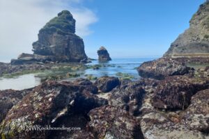
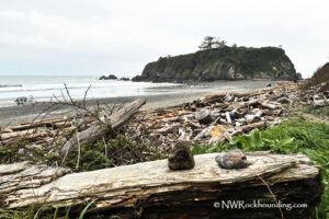
The Chetco River has extensive gravel bars, especially in the lower section. These areas are easily accessible and rich with cool rocks.
Among the treasures you can find are jasper, agate, and petrified wood, along with quartz, carnelian agate, and serpentine.
Quartz is generally milky-white and sometimes contains mineral impurities. Jasper is commonly green, brown, or red brecciated and is often found in large pieces throughout the river gravels.
Several excellent spots along the lower Chetco River allow you to drive directly to the riverbank.
The most remarkable rockhounding sites are Social Security Bar, Alfred Loeb State Park, Miller Bar, Redwood Bar, Nook Bar, Gardner Bar, Low Water Bridge, and South Fork.

Beyond the Rocks: Exploring the Area
The Chetco River is renowned for its fishing, swimming, hiking, whitewater rafting, kayaking, camping, and picnicking opportunities.
Fishing: The river is best known for its winter steelhead runs (from December to February) and fall Chinook salmon runs (from September to December).
Swimming: The lower section has the best swimming holes with easy access to the riverbank. If you prefer more adventure and fewer people, there are swimming holes at the Kalmiopsis Wilderness in the upper Chetco, though reaching them requires a challenging hike.
Hiking: There are multiple hiking trails along the river. An easy out-and-back 1.5-mile trail, Riverview Nature Trail, with a trailhead at Alfred Loeb State Park, will take you along the scenic Chetco River to the Rogue River Siskiyou National Forest. A short but enchanting 1.7-mile route, Chetco Gorge Trail offers breathtaking views of the Chetco Gorge, where the river has carved out deep, dramatic canyons.
Kayaking: The river's rugged terrain is excellent for whitewater rafting and kayaking. Northwest Rafting Company organizes 5-day guided whitewater rafting expeditions through the upper section of the Chetco River.
Camping and Picnicking: There are plenty of campgrounds and recreation areas along the river for camping and picnicking in scenic surroundings.
Chetco River | Facts
Material: White quartz, agate, petrified wood, serpentine, and green, brown, and red brecciated jasper; Gold
Tools: Sand Dipper Square Scoop
Land type: Rocky river
Best time to visit: Year-round
Land managers: Oregon State Parks and Bureau of Land Management (BLM)
Fees: None
Location: Brookings • Oregon • USA
Road access: Any vehicle
Elevation: 100-200 ft (30-61 m)
Places to Stay Near Chetco River
You can stay at one of the several campgrounds on the Chetco River. Alfred A. Loeb State Park is the biggest and most developed campsite of all.
It has 53 electrical sites and 3 rustic log cabins, including one accessible cabin. Every spot has a picnic table and a fire ring. On-site amenities include firewood for sale, hot showers, and flush toilets. Reservations are required through the Oregon State Parks Reservation System.
Other campgrounds include Nook Bar Campground, Redwood Bar Campground, and South Fork Campground. These 3 operate on a first-come, first-served basis and have fewer amenities than Alfred A. Loeb State Park.
Alternatively, you can stay at one of Brookings' multiple hotels and rentals.
Affordable long and short-term vacation rentals in Brookings
You May Also Like


Chetco River Directions
From Highway 101 in Brookings,
- Turn north to North Bank Chetco River Road and then bear right staying on North Bank Chetco River Road
- Travel 3.2 miles northeast to Social Security Bar on the right
- Follow the next 8 miles to Miller Bar
- Continue 3.4 miles to Redwood Bar.
Social Security Bar: N 42°3.853' W 124°13.799' | 42.064221, -124.229976
Miller Bar: N 42°08.347' W 124°10.742' | 42.139117, -124.179033
Redwood Bar: N 42°09.327' W 124°08.724' | 42.155450, -124.145401