

The wild and scenic Elk River originates in the Salmon Mountain and Grassy Knob Wilderness and flows through the Rogue River-Siskiyou National Forest for about 30 miles before emptying into the Pacific Ocean.
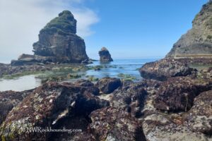
The river is known for its clear, emerald-green water, beautiful scenery, and many outdoor activities, including rockhounding.
Much of the lower river runs through private land and is not easily accessible. However, about 17 miles of the upper part, from the confluence of the North and South Forks to the Elk River Fish Hatchery, are open to the public.
The Elk River and the South Fork of the Sixes River drain parts of the Copper-Salmon and Grassy Knob Wilderness areas.
These regions, including the Myrtle Group, are a geologic formation composed of shale and sandstone that contains fossils dating to about 66 to 145 million years ago.
Elk River Rockhounding
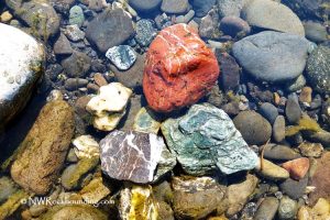
In the riverbed and nearby gravel bars, you can find pieces of shale with plant fossils, as well as quartz and chert. The quartz is usually milky, while chert ranges in color from gray and green to yellow and red, with reddish chert being the most common.
No special tools are needed, but a Sand Dipper Square Scoop can make collecting easier, especially in gravel areas.
The Elk River is also a popular spot for recreational gold panning.
There are several access points along the river. Sunshine Bar Campground and Butler Bar Campground are among the easiest places to reach.
Keep in mind that some sections of the river are closed to collecting. It includes the quarter-mile stretch near the Elk River Fish Hatchery and parts of the North Fork upstream toward the falls.

Things to Do at Elk River: Exploring the Area
Elk River is a popular fishing destination, especially for fall Chinook salmon, wild winter steelhead, and sea-run cutthroat.
About 2 miles below Bald Mountain Creek are open for fishing, and around 13 miles of private land below the Elk River Hatchery can also be accessed for fishing by drift boat.
The river is also great for swimming, rafting, tubing, and kayaking. Even in summer, the water stays cool.

Elk River | Facts
Material: Plant fossils, quartz, and chert; Gold
Tools: Sand Dipper Square Scoop
Land type: Coastal river
Best time to visit: Year-round
Land manager: U.S. Forest Service
Fees: None
Location: 19 miles southeast of Port Orford • Oregon • USA
Road access: Any vehicle
Elevation: 400-600 ft (122-183 m)
Places to Stay Near Elk River
Sunshine Bar Campground and Butler Bar Campground are two good camping spots along the Elk River, and both are free.
Sunshine Bar Campground has 6 campsites with picnic tables and fire pits.
Butler Bar Campground has 7 campsites with picnic tables and fire pits.
Alternatively, you can get a hotel in Gold Beach.
You May Also Like


Elk River Directions
From Port Orford,
- Head north on US-101 North for 3.1 miles
- Turn right onto Elk River Road and follow it for 14 miles to Sunshine Bar Campground.
Sunshine Bar Campground: N 42°42.745' W 124°18.645' | 42.7124, -124.31075
- Continue on Elk River Road 3.2 miles to Butler Bar Campground.
Butler Bar Campground: N 42°43.551' W 124°16.254' | 42.72585, -124.2709
In addition, about 1.5 miles before reaching Sunshine Bar Campground, there is a wide stretch of gravels.
Gravel stretch: N 42°42.531' W 124°19.938' | 42.70885, -124.3323