

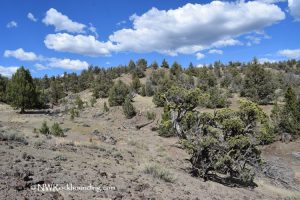
Eagle Rock, located 16 miles southeast of Prineville, is a rugged and scenic destination for rockhounding enthusiasts. This designated BLM rockhounding site is also featured on the Central Oregon Rockhounding Map, which available for purchase.
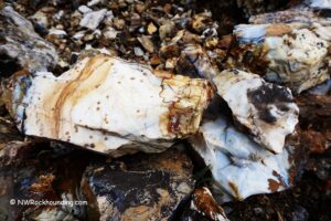
The steep, juniper-covered terrain is known for its agate and jasper specimens, including the famed Eagle Rock Plume Agate, a distinctive and highly prized material known among rock collectors.
Although navigating the rough landscape requires some effort, the rewards include interesting geological finds and breathtaking views that make the journey worthwhile.

Eagle Rock Rockhounding
The site is particularly famous for plume agate, which has become scarce but can still be found with some effort. Other varieties of agate and jasper can also be found here, making Eagle Rock a rewarding destination for rockhounds.
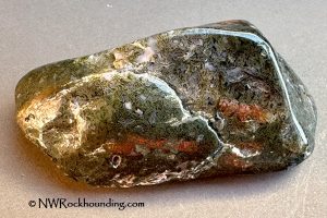
Plume agate comes in black and brown colors with intricate, feather-like patterns, while moss agate features mossy, plant-like inclusions in shades of green, red, and brown. Jasper occurs in red, yellow, orange, and brown varieties. You may also find botryoidal agate, with rounded, bubbly formations that can resemble clusters of grapes.
Surface collecting is often the easiest way to search the area. If you dig with hand tools, stay away from steep slopes, overhangs, and deep holes. Follow current BLM collecting rules and avoid damaging the surrounding landscape.
After seasonal rains, newly exposed rocks may be easier to find. With some patience, Eagle Rock can be a great place to find interesting rocks and enjoy the outdoors.


Know Before You Go
The Eagle Rock area is remote and rugged, so prepare accordingly.
- Vehicle Requirements: The gravel roads can be rough, and a high-clearance 4WD vehicle is recommended, especially after rain.
- Lack of Services: There are no restrooms, water, or stores nearby. Bring all necessary supplies, including plenty of water, snacks, sunscreen, and a first-aid kit.
- Wildlife Precautions: Watch for wildlife, including rattlesnakes. Wear sturdy boots and stay alert while hiking and rockhounding.
- Personal Safety: With limited cell service, inform someone of your travel plans. Consider carrying a satellite phone for emergencies.
- Safety Preparations: Familiarize yourself with desert safety practices to better prepare for the unique challenges of this remote area.

Beyond the Rocks: Exploring the Area
The area around Eagle Rock offers more than just rockhounding. It’s also a great place to enjoy outdoor activities and the natural beauty of the region.
The Eagle Rock trail offers a rewarding challenge for adventurous hikers. The hike to the collecting area is about 0.7 miles from the closer trailhead and follows a rocky, uphill route to the site. The rough and occasionally slippery terrain calls for sturdy footwear, while hiking poles can provide additional stability.
Nearby Prineville Reservoir is a great place for outdoor activities. You can camp, fish for bass, trout, and crappie, or enjoy swimming and boating. Trails around the reservoir are also good for hiking and wildlife viewing.
For a great side trip, head west to the Painted Hills, part of the John Day Fossil Beds National Monument. The colorful, layered hills show the area's geologic history and are a great place to explore nature and geology.

Eagle Rock | Facts
Material: Agate, jasper, chalcedony, petrified wood, and quartz
Tools: Geology pick, hammer, and chisel
Land type: High desert
Best time to visit: May to October
Land manager: Bureau of Land Management (BLM)
Fees: None
Location: 16 miles southeast of Prineville • Oregon • USA
Road access: A high-clearance 4WD vehicle is recommended
Elevation: 4,500 ft (1,463 m)
Places to Stay Near Eagle Rock
Eagle Rock is located on Bureau of Land Management (BLM) lands, which are generally open to dispersed camping, offering a rugged and serene experience under the stars.
For those preferring more established sites, the nearest campground is at Prineville Reservoir State Park, where you can enjoy lakeside camping with amenities. Another great option is Elkhorn Campground, located nearby and featuring an agate bed for rockhounding enthusiasts.
If camping isn’t your style, Prineville offers a range of lodging and vacation rental options, providing a comfortable base for exploring the area.
Affordable vacation rentals for short and long-term stays at Prineville
You May Also Like




Eagle Rock Directions & Contacts
From Prineville,
- Follow Paulina Highway (Highway 380) toward Post for about 15 miles
- Turn right onto a gravel road between mileposts 14 and 15
- After the cattle guard, bear left and continue uphill for 0.9 miles to the first fork
- Bear right, open and close the gate, and continue 0.4 miles to the second fork and trail on the left.
From there, hike uphill for 0.6 miles to a fork at the hilltop, then head left for 0.1 miles to reach the collection site.
GPS (Trailhead): N 44°11.296' W 120°39.936' | 44.188, -120.67
GPS (Collecting Area): N 44°11.131' W 120°40.119' | 44.185, -120.67