

Nestled deep within the scenic ponderosa pine forest of the Ochoco Mountains, approximately 50 miles away from Prineville, Whistler Springs stands as a recreational rockhounding area and campground. The area is featured on the Central Oregon Rockhounding Map which is available for purchase.
It's important to note that the site shares its border with Mill Creek Wilderness to the south, where digging is prohibited. Pay attention to signs and fences separating two areas.
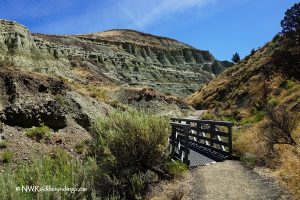
Wildcat Trail (#833) starts at the Wildcat North Trailhead (parking area) near Site 1 and runs through the eastern part of Mill Creek Wilderness. Please, refer to the map of Mill Creek Wilderness and trails for more information.
The road to Whistler Springs is rough and bumpy, and during the rainy season, it becomes muddy as well. Four-wheel drive is highly recommended to get through this part of the road. Do not travel to Whistler Springs on recreational vehicles and trailers due to the roughness of the road.

Whistler Springs Rockhounding
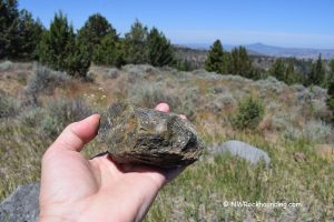
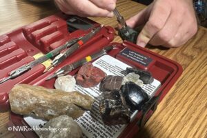
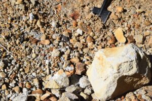
Though this area has been a popular destination for decades, high-quality thundereggs filled with agate or jasper, typically ranging from 2 to 4 inches in size, can still be found. Beyond thundereggs, the site also reveals other treasures such as petrified wood, jasper, and agate.
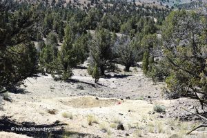
There are two digging areas, both located 0.1 miles from each other and 0.5 miles from Whistler Springs Campground. Pay attention to past diggings left by others. You can not only dig deeper to find more material but also collect plenty of minerals left behind by previous visitors.
The best material can be obtained by digging through a rhyolite matrix. It might be harder and will require tools like a shovel, gad, chisel, and hammer, but it will give you a chance to add nicer rocks to your collection.

Beyond the Rocks: Exploring the Area
Ochoco National Forest stretches over 50 miles from west to east, presenting a breathtaking landscape that features vast pine forests, towering mountains, rugged canyons, and scenic high desert terrain. The forest’s diverse scenery is enriched by clear lakes and rivers, making it a paradise for nature lovers.
Popular activities in the forest include hiking, camping, fishing, horseback riding, wildlife viewing, and, of course, rockhounding. The Wildcat Trail, which runs 9 miles through Mill Creek Wilderness from Whistler Springs to White Rock Campground, offers a scenic route for outdoor enthusiasts.

Another popular public rockhounding site, White Fir Springs is located a few miles away. If you're interested in famous Lucky Strike thundereggs, Lucky Strike Mine nearby offers the pay-to-dig options are also nearby.
Prineville, the oldest city in Central Oregon, is known as the unofficial World Rock Hound Capital. Each June, Prineville hosts the Rockhound Pow Wow Festival at the Crook County Fairgrounds, where over 60 dealers sell agate, jasper, petrified wood, obsidian, thundereggs, both new and used lapidary equipment, gifts, and jewelry.
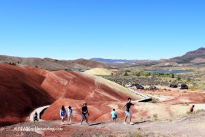
Additionally, Prineville is recognized as the Getaway to the John Day Fossil Beds, which boasts the world's most extensive fossil collection, as well as the Painted Hills, a striking geological phenomenon.
Whistler Springs | Facts
Material: Thundereggs, petrified wood, agate, jasper
Tools: Rock hammer, shovel, gad, and chisel
Land type: Forested mountains
Best time to visit: From May to October
Land manager: US Forest Service - Ochoco National Forest
Fees: None
Location: 37 miles east of Prineville • Oregon • USA
Road access: A high-clearance 4WD vehicle
Elevation: 5,600 ft (1,707 m)
Places to Stay Near Whistler Springs
The free campground, available on a first-come, first-served basis, is located within walking distance from the collecting area and the Wildcat North Trailhead. Be cautious of the many standing dead trees when setting up camp.
Additionally, dispersed camping is allowed in the Ochoco National Forest.
Prineville, located 37 miles southwest, offers a range of affordable lodging options and vacation rentals, providing visitors with budget-friendly accommodation choices.
Affordable vacation rentals for short and long term stay at Prineville
You May Also Like


Whistler Springs Directions
There are two ways to get to this place. One of those, provided by Prineville Chamber of Commerce, is shorter but with narrow and winding sections. Another is longer but easier route.
From Prineville,
1. A longer but easier route.
- Drive east via Highway 26 to milepost 49 and then 0.4 miles after milepost 49 to Forest Road 27
- Turn left onto Forest Road 27 and drive 1.3 miles to Forest Road 2730
- Turn right onto Forest Road 27 and continue 6 miles to the fork, bear left and continue 3.3 miles to Forest Road 200.
- Turn left onto NF 200, go 1.3 miles to Lucky Strike Mine Sign on the right
- Continue for about 5 miles to Whistler Springs Campground.
As the road goes left, take a primitive road to the right. Go down 0.3 miles. As you cross a cattle garden, park your car on the right. You will find a pit near the parking area if you walk west along the trail from a fire pit. Other digging sites are 0.1 miles south on the road that goes on the left.
2. A shorter route with narrow and winding sections. Do not use this route during the rainy season since it can become impassable.
- Drive east via Highway 26 to milepost 49; continue 0.4 miles after milepost 49 to Forest Road 27
- Turn left onto Forest Road 27 and go for about 6 miles, turn left on Forest Road 2700, then take Forest Road to Whistler Springs Campground.
Phone (Ochoco National Forest): 541-416-6500