
Located about 7 miles northeast of Fields, Borax Lake and Borax Hot Springs form one of the most unusual geological areas in southeastern Oregon.
This small geothermal area, known for hot springs, mineral-rich deposits, volcanic landscapes, and striking desert scenery, sits at the base of Steens Mountain in the remote Alvord Basin.
It feels like the edge of the world, which is part of its appeal.
Although Borax Lake and the hot springs themselves are protected, and collecting is not permitted within the preserve, the surrounding region, managed by BLM, offers opportunities to collect a variety of volcanic and mineral-rich rocks.
Geological History of Borax Lake Area
The Borax Lake area lies within the Basin and Range Province of southeastern Oregon, a region shaped by crustal extension, normal faulting, and associated volcanism over millions of years.
During the Miocene Epoch, extensive volcanic activity—including basaltic flows and rhyolitic eruptions—helped build much of the surrounding landscape of southeastern Oregon.
Continued crustal stretching produced fault-block mountains such as nearby Steens Mountain and created the basin-and-range topography seen today.
Groundwater heated at depth circulates along faults and fractures, producing the geothermal activity observed at Borax Lake and nearby hot springs.
The name “Borax Lake” reflects naturally occurring borate minerals in the area.
Although borate prospecting occurred in the late 1800s, the deposits were not sufficient to support large-scale commercial production.
Rockhounding at Borax Lake Area
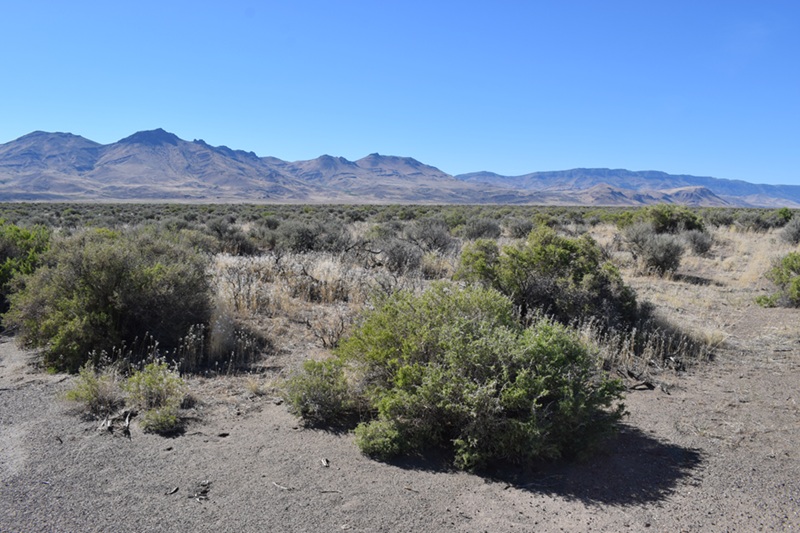
Collecting can start at any place along the last two miles of the road before you reach a fence and a trailhead leading to Borax Lake.
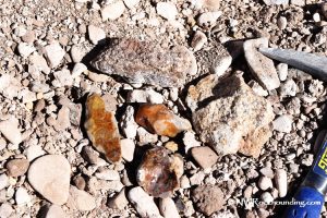
Here's the good news: you'll find material the whole way in. I'm not exaggerating. The first time I drove this road, I almost missed a great pullout because I was busy watching the washboard ruts. Pay attention, and you'll spot rocks scattered right along the route.
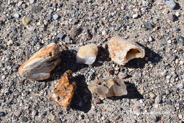
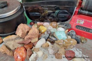
What can you pick up here? Quite a bit, actually. Keep your eyes peeled for:
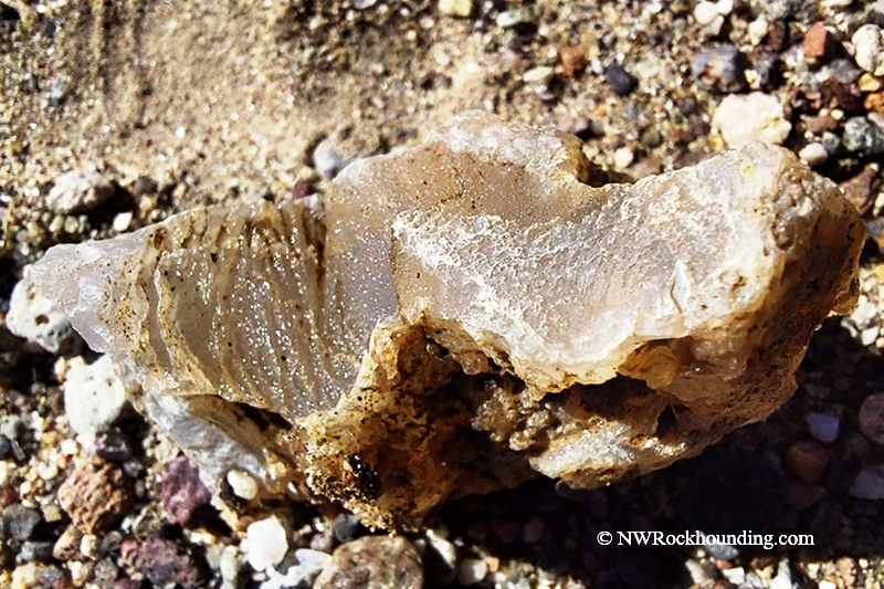
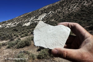
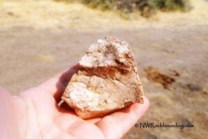
- Agate in soft, milky, yellow, and brown colors
- Jasper with warm reds and yellows
- Petrified wood
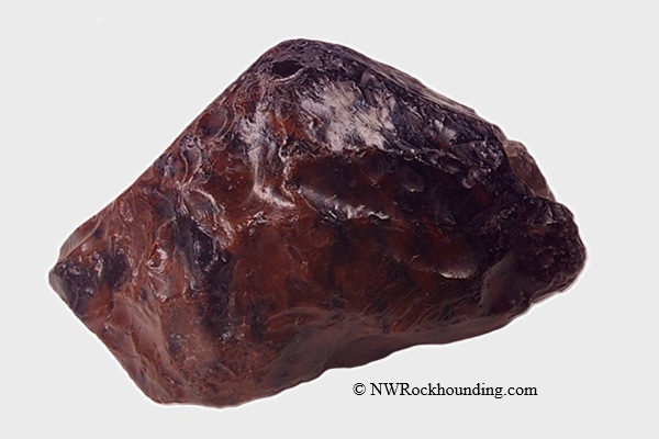
- Obsidian, including mahogany obsidian, and apache tears
- Fossils.
You won't need fancy gear. A simple geology pick does the job.
🔵 The road is washboard for most of the way, and I really don't recommend trying it after rain. The dirt turns to slick mud fast, and getting stuck out here means a long, lonely wait.
Exploring Borax Lake Area: Things to Do Nearby
This lonely stretch of Oregon's high desert offers far more than just rocks.
From the parking area near the gate, you can follow a trail to Borax Lake and Borax Hot Springs and its remarkable geothermal features.
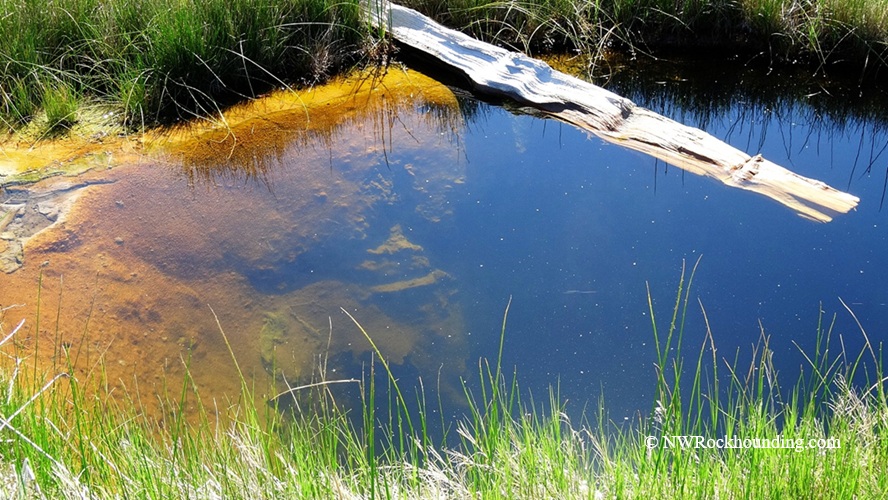
The steamy 10-acre lake lies in the middle of a bone-dry desert, fed by a powerful underground spring.
The hot springs are located just north of the lake. Water emerging from deep below the surface reaches nearly 196°F (91°C), creating one of Oregon's most unusual desert landscapes.
🔴 Borax Hot Springs is genuinely dangerous. The water nears the boiling point, and the thin crust of the ground can break underfoot, dropping you into scalding water. Stay on solid ground, obey the posted signs, and keep kids and pets close.
🟡 Borax Lake is a protected biological preserve and home to the rare Borax Lake chub, so swimming and soaking are banned.
The wider Alvord Desert is the area's biggest attraction. This massive dry playa stretches below Steens Mountain and draws visitors for camping, stargazing, photography, and pure solitude.
Have you ever stood somewhere so vast and empty that it makes you feel tiny? That is the Alvord Playa.
Looking for a soak?
Alvord Hot Springs lies a couple of miles north and offers developed soaking pools, while Mickey Hot Springs, often called "Little Yellowstone", for its colorful geothermal features and bubbling vents—sits about 4 miles away along the same fault system.
Before heading home, consider stopping at Fields Station for one of its famous milkshakes. After a dusty day in the desert, it is a well-earned treat.
Borax Lake Rockhounding | Facts
Material: Agate, jasper, petrified wood, obsidian, apache tears
Tools: Geology pick
Land type: Sagebrush high desert
Best time to visit: Late spring through fall
Land manager: Bureau of Land Management (BLM) - Burns
Fees: None
Location: Harney County • Oregon • USA
Road access: 4WD suggested
Camping and Lodging at Borax Lake
Camping is not allowed within the Borax Lake and the Hot Springs area. However, primitive camping is available at Mann Lake and Alvord Playa.
Alvord Hot Springs has multiple accommodation options, including bunkhouses and campsites.
The nearest lodging options are available in Hines and Burns.
Affordable vacation rentals for short and long term stay in Hines-Burns Area
You May Also Like


Borax Collecting Site Directions
From Fields,
- Travel north 1.4 miles to the junction of Highway 205 and Fields-Denio Road (Folly Farm Road or East Steens Road)
- At the junction, bear right and go 0.25 miles to the power substation
- Turn right immediately after the power substation and follow the dirt road that parallels the power lines for about 2 miles
- Turn left and and continue until you find a suitable pullout along the road.
GPS (pullout we used): N 42°18.153' W 118°37.483' | 42.3024, - 118.6246