

Succor Creek is a remote high-desert destination situated along Oregon’s eastern border with Idaho. Nestled at the base of the scenic Succor Creek Canyon, this area is known for its striking rhyolite formations that line Succor Creek Road and its colorful cliffs, which rise hundreds of feet above the canyon floor.
The canyon itself is a dramatic geological formation, shaped by volcanic activity from the Three Fingers Caldera during the middle to late Miocene epoch. Based on fossilized plants and vertebrates found in the area, the volcanic eruption that gave rise to the landscape occurred roughly 16 to 15 million years ago.
Succor Creek originates in Idaho’s Owyhee Mountains and flows for 23 miles before crossing into Oregon. Once in Oregon, the creek continues northward for another 39 miles before re-entering Idaho and eventually merging with the Snake River near the town of Homedale.
Along its journey, Succor Creek has carved through the rugged terrain, transforming a mountainous region of Oregon into a scenic oasis amidst the vast high desert.

Driving the 52-mile stretch through the rugged, scenic Succor Creek Canyon is an adventure in itself. The canyon’s unique geology, carved by the creek over millions of years, invites exploration.
You can hike or mountain bike to the canyon rim, where you’ll be rewarded with stunning views of the Owyhee Mountains and the surrounding landscape. Along the way, you can also discover numerous caves sculpted into the cliffs by the forces of wind, water, and time.
The area is a popular destination for hikers, bikers, ATV riders, and rock collectors alike. ATV riding is especially popular here.
It's interesting to note that while all off-road vehicles are prohibited within state parks, once you cross the park boundaries onto land managed by the Bureau of Land Management (BLM), ATVs are permitted. This creates a unique contrast, offering outdoor enthusiasts a balance between protected, vehicle-free natural areas and nearby spots where off-road exploration is allowed.
Succor Creek Road, which is partially dirt and gravel, is best navigated with a 4WD vehicle. The northern section of Succor Creek Road, accessible from Highway 201 approximately 8.5 miles south of Adrian, is wider and less winding compared to the southern route, making it more suitable for trailers and recreational vehicles (RVs).
During dry seasons, most two-wheel drive high-clearance vehicles can manage this route. However, driving from Jordan Valley involves a longer route with narrow, winding roads in certain areas.

Succor Creek Rockhounding
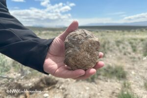
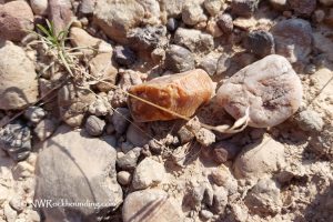
The Succor Creek ravine is a treasure trove for rockhounding enthusiasts, offering a wealth of fossilized plants, petrified wood, and agate. However, the area is perhaps best known for its abundance of thundereggs and picture jasper, making it a prime destination for collectors.
While driving along Succor Creek Road, it’s worth stopping at various spots to explore the extensive gravel areas, dry washes, creek beds, and hillsides. These locations are excellent for discovering picture jasper, agate, quartz, and petrified wood. Additionally, plant fossils can often be found in ancient lake sediments and volcanic ash deposits.

The main thunderegg bed is located within the Succor Creek State Natural Area, just across the creek. To reach it, cross the bridge and follow the trails that lead up the hill. While surface collecting is possible, you’ll likely find better material by digging through the tough rhyolite matrix with appropriate tools.
In addition to rockhounding, Succor Creek is known for its stunning landscapes, which offer breathtaking vistas, excellent hiking trails, and opportunities for wildlife watching, making it a well-rounded destination for outdoor enthusiasts.

Beyond the Rocks: Exploring the Area
If you're eager to collect more rocks, consider visiting other productive locations in the Owyhee Canyonlands:
- Haystack Butte: A prime spot to search for the rare and colorful Jellybean Jasper.
- Twin Springs: Known for producing high-quality jasper and agate.
- Negro Rock: A great location to uncover petrified wood.
- Graveyard Point: Famous for its beautiful plume agates and striking black dendrites.
The Owyhee Canyonlands is a rugged and scenic wilderness tucked into the most remote corner of Oregon. Over millions of years, the Owyhee River and its tributaries have carved deep canyons through volcanic tuff, rhyolite, and basalt, while wind and time have further shaped these ancient volcanic formations.
This remote wilderness area draws visitors with its diverse array of outdoor activities. The Leslie Gulch area boasts breathtaking hiking trails that wind through dramatic rock formations, offering stunning views.
Owyhee Lake provides excellent opportunities for boating and fishing, while along the banks of the Owyhee River, you can unwind and soak in the soothing waters of Snively Hot Springs.
For experienced adventurers, the Owyhee River provides an exhilarating challenge for rafters from March through July. Navigating Class III and IV rapids requires skill and expertise, as the river’s unpredictable currents and narrow passages demand precision and caution.
Know Before You Go:
- Summer weather is torrid and dehydration is a serious threat. Escape the summer heat and stay hydrated.
- Watch for poison ivy and rattlesnakes.
- Check Desert Safety Tips.
Succor Creek Canyon | Facts
Material: Thundereggs, picture jasper, agate, petrified wood, and plant fossils
Tools: Rock hammer, shovel, gad, and chisel
Land type: High desert and hills
Best time to visit: From May to October
Land manager: Bureau of Land Management (BLM), Oregon State Parks
Fees: None
Location: 18 miles southeast of Homedale • Idaho • USA
Road access: A high-clearance 4WD vehicle is suggested
Elevation: 2,800 ft (853 m)
Places to Stay Near Succor Creek Rockhounding Area
Succor Creek Campground spans both sides of the creek and provides a primitive camping experience. The campground offers picnic tables and vault toilets, but there are no RV hookups or drinking water available. The west side of the campground is suitable for RVs and trailers, while the east side is better suited for tents or vans.
Succor Creek State Natural Area also features primitive camping along the creek, with the east side designated for tents and vans, and the west side for RVs and trailers. Basic amenities include picnic tables and vault toilets, but there is no drinking water or cell phone service, so visitors should come prepared.
Affordable vacation rentals for short and long term stay at Homedale
Affordable vacation rentals for short and long term stay at Ontario
You May Also Like


Succor Creek Directions
From Homedale in Idaho,
- Travel 5 miles west on Highway 19 in Idaho and 1.8 miles on Highway 201 in Oregon to Succor Creek Road
- Turn left (south) on Succor Creek Road and continue 12 miles to Site 1
- Continue for 3.5 miles to the day-use and campground (Site 2).
Phone (Oregon State Parks): 800-551-6949
stateparks.oregon.gov
Site 1 - Gravels: N 43°30.022' W 117°07.776' | 43.500, -117.130